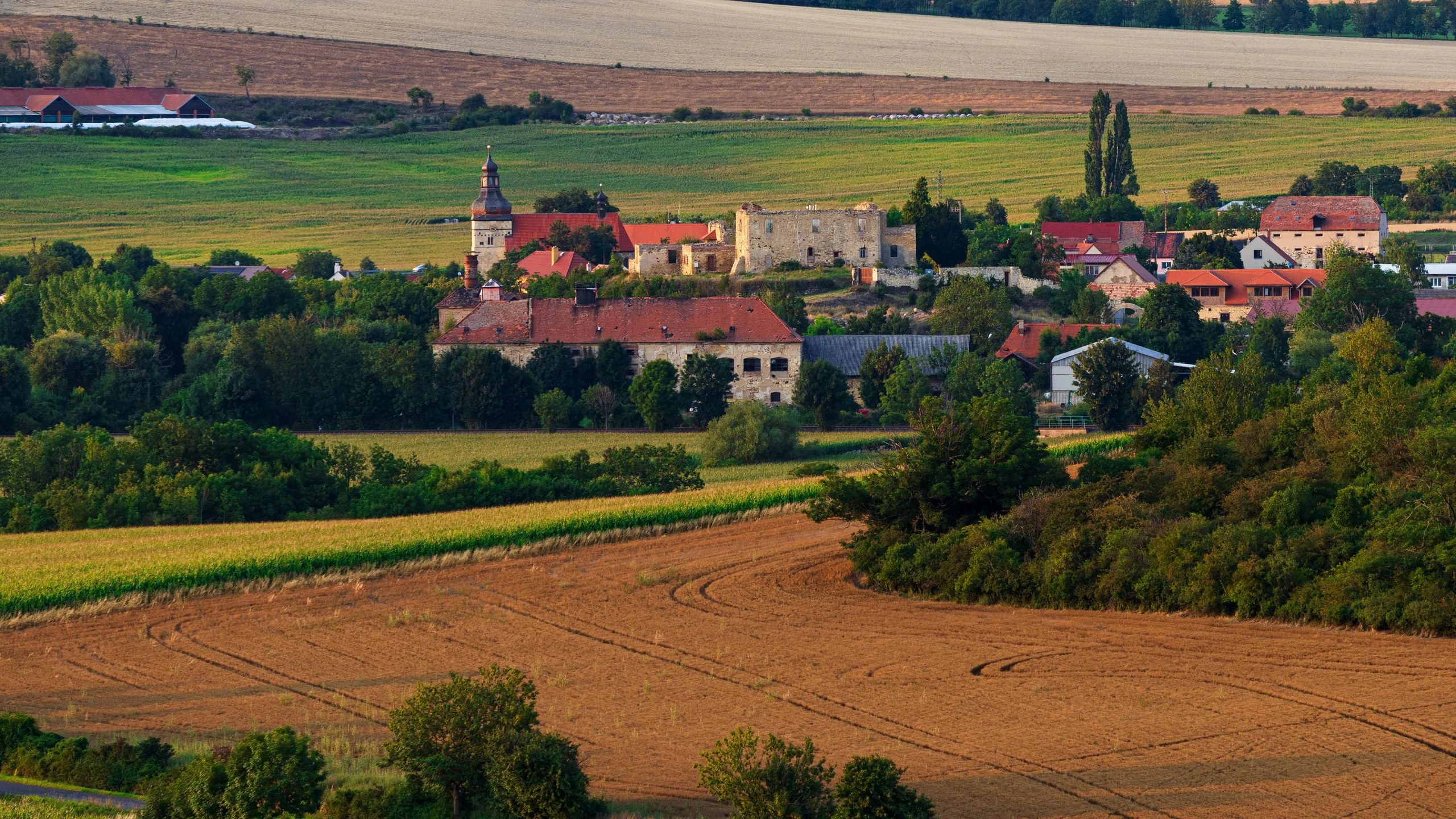
The Szádvár Trail, held in Szögliget, Hungary, features race distances of 9.7 km, 21.7 km, 43 km, and 69 km. As part of the ITRA National League, participants can earn ITRA points. The trail takes runners through the scenic Aggtelek Karst, offering a challenging and rewarding experience. The event is organized by the Edelényi Futók Egyesülete and includes amenities such as electronic timing and unique finisher medals.
Races
The Szádvár Trail Vitéz kör is a fun and accessible 9.72 km trail race, ideal for runners seeking a taste of the Aggtelek Karst’s natural scenery. It combines forest paths and rocky trails, offering a rewarding outdoor experience for beginners and casual trail runners.
The Szádvár Trail Lovag kör takes runners on a 21.7 km journey through scenic forest trails and rugged terrain. This race is perfect for those looking for a mid-distance challenge with beautiful views of the karst landscape.
The Szádvár Trail Kapitány kör covers 43 km of varied trail terrain, including paths, rocky tracks, and forested areas. This race challenges participants with substantial elevation gain while offering scenic views of the Aggtelek Karst and historic landmarks along the route.
The Szádvár Trail Ultra is a challenging 69 km trail race through the scenic Aggtelek Karst region. Participants will navigate wild hills, valleys, and forested areas, with significant elevation changes.
Weather based on historical averages.
FAQs
What is the Szádvár Trail Vitéz kör 9.7km?
How long is the Szádvár Trail Vitéz kör 9.7km?
Where does the Szádvár Trail Vitéz kör 9.7km take place?
What is the elevation gain of the Szádvár Trail Vitéz kör 9.7km?
How can I prepare for the Szádvár Trail Vitéz kör 9.7km?
How do I choose the right training plan for the Szádvár Trail Vitéz kör 9.7km?
The Szádvár Trail Vitéz kör is a fun and accessible 9.72 km trail race, ideal for runners seeking a taste of the Aggtelek Karst’s natural scenery. It combines forest paths and rocky trails, offering a rewarding outdoor experience for beginners and casual trail runners.
The Szádvár Trail Vitéz kör 9.7km is 9km long.
The Szádvár Trail Vitéz kör 9.7km takes place in Szögliget, Hungary.
The Szádvár Trail Vitéz kör 9.7km elevation gain is 433 meters, which Runna classifies as a Hilly race.
The best way to train for the next race is to use a personalized training plan that takes into account your current running ability, schedule, and preferences.
This will help you steadily improve your running performance and get ready for the race without risking an injury.
Check out our training plans to find the best running program for your goals!
Which plan you choose will depend on your experience, schedule, objectives, and the date of the race.
Runna offers personalized training plans for every runner and every goal: Whether this is your first, 10th or 100th race, we'll help you get the most out of your training and smash your goals.
Check out our training plans to find the best running program for your goals!
What is the Szádvár Trail Vitéz kör 9.7km?
The Szádvár Trail Vitéz kör is a fun and accessible 9.72 km trail race, ideal for runners seeking a taste of the Aggtelek Karst’s natural scenery. It combines forest paths and rocky trails, offering a rewarding outdoor experience for beginners and casual trail runners.
How long is the Szádvár Trail Vitéz kör 9.7km?
The Szádvár Trail Vitéz kör 9.7km is 9km long.
Where does the Szádvár Trail Vitéz kör 9.7km take place?
The Szádvár Trail Vitéz kör 9.7km takes place in Szögliget, Hungary.
What is the elevation gain of the Szádvár Trail Vitéz kör 9.7km?
The Szádvár Trail Vitéz kör 9.7km elevation gain is 433 meters, which Runna classifies as a Hilly race.
How can I prepare for the Szádvár Trail Vitéz kör 9.7km?
The best way to train for the next race is to use a personalized training plan that takes into account your current running ability, schedule, and preferences.
This will help you steadily improve your running performance and get ready for the race without risking an injury.
Check out our training plans to find the best running program for your goals!
How do I choose the right training plan for the Szádvár Trail Vitéz kör 9.7km?
Which plan you choose will depend on your experience, schedule, objectives, and the date of the race.
Runna offers personalized training plans for every runner and every goal: Whether this is your first, 10th or 100th race, we'll help you get the most out of your training and smash your goals.
Check out our training plans to find the best running program for your goals!
What is the Szádvár Trail Lovag kör 21.7km?
How long is the Szádvár Trail Lovag kör 21.7km?
Where does the Szádvár Trail Lovag kör 21.7km take place?
What is the elevation gain of the Szádvár Trail Lovag kör 21.7km?
How can I prepare for the Szádvár Trail Lovag kör 21.7km?
How do I choose the right training plan for the Szádvár Trail Lovag kör 21.7km?
The Szádvár Trail Lovag kör takes runners on a 21.7 km journey through scenic forest trails and rugged terrain. This race is perfect for those looking for a mid-distance challenge with beautiful views of the karst landscape.
The Szádvár Trail Lovag kör 21.7km is 21km long.
The Szádvár Trail Lovag kör 21.7km takes place in Szögliget, Hungary.
The Szádvár Trail Lovag kör 21.7km elevation gain is 838 meters, which Runna classifies as a Hilly race.
The best way to train for the next race is to use a personalized training plan that takes into account your current running ability, schedule, and preferences.
This will help you steadily improve your running performance and get ready for the race without risking an injury.
Check out our training plans to find the best running program for your goals!
Which plan you choose will depend on your experience, schedule, objectives, and the date of the race.
Runna offers personalized training plans for every runner and every goal: Whether this is your first, 10th or 100th race, we'll help you get the most out of your training and smash your goals.
Check out our training plans to find the best running program for your goals!
What is the Szádvár Trail Lovag kör 21.7km?
The Szádvár Trail Lovag kör takes runners on a 21.7 km journey through scenic forest trails and rugged terrain. This race is perfect for those looking for a mid-distance challenge with beautiful views of the karst landscape.
How long is the Szádvár Trail Lovag kör 21.7km?
The Szádvár Trail Lovag kör 21.7km is 21km long.
Where does the Szádvár Trail Lovag kör 21.7km take place?
The Szádvár Trail Lovag kör 21.7km takes place in Szögliget, Hungary.
What is the elevation gain of the Szádvár Trail Lovag kör 21.7km?
The Szádvár Trail Lovag kör 21.7km elevation gain is 838 meters, which Runna classifies as a Hilly race.
How can I prepare for the Szádvár Trail Lovag kör 21.7km?
The best way to train for the next race is to use a personalized training plan that takes into account your current running ability, schedule, and preferences.
This will help you steadily improve your running performance and get ready for the race without risking an injury.
Check out our training plans to find the best running program for your goals!
How do I choose the right training plan for the Szádvár Trail Lovag kör 21.7km?
Which plan you choose will depend on your experience, schedule, objectives, and the date of the race.
Runna offers personalized training plans for every runner and every goal: Whether this is your first, 10th or 100th race, we'll help you get the most out of your training and smash your goals.
Check out our training plans to find the best running program for your goals!
What is the Szádvár Trail Kapitány kör 43km?
How long is the Szádvár Trail Kapitány kör 43km?
Where does the Szádvár Trail Kapitány kör 43km take place?
What is the elevation gain of the Szádvár Trail Kapitány kör 43km?
How can I prepare for the Szádvár Trail Kapitány kör 43km?
How do I choose the right training plan for the Szádvár Trail Kapitány kör 43km?
The Szádvár Trail Kapitány kör covers 43 km of varied trail terrain, including paths, rocky tracks, and forested areas. This race challenges participants with substantial elevation gain while offering scenic views of the Aggtelek Karst and historic landmarks along the route.
The Szádvár Trail Kapitány kör 43km is 43km long.
The Szádvár Trail Kapitány kör 43km takes place in Szögliget, Hungary.
The Szádvár Trail Kapitány kör 43km elevation gain is 1500 meters, which Runna classifies as a Hilly race.
The best way to train for the next race is to use a personalized training plan that takes into account your current running ability, schedule, and preferences.
This will help you steadily improve your running performance and get ready for the race without risking an injury.
Check out our training plans to find the best running program for your goals!
Which plan you choose will depend on your experience, schedule, objectives, and the date of the race.
Runna offers personalized training plans for every runner and every goal: Whether this is your first, 10th or 100th race, we'll help you get the most out of your training and smash your goals.
Check out our training plans to find the best running program for your goals!
What is the Szádvár Trail Kapitány kör 43km?
The Szádvár Trail Kapitány kör covers 43 km of varied trail terrain, including paths, rocky tracks, and forested areas. This race challenges participants with substantial elevation gain while offering scenic views of the Aggtelek Karst and historic landmarks along the route.
How long is the Szádvár Trail Kapitány kör 43km?
The Szádvár Trail Kapitány kör 43km is 43km long.
Where does the Szádvár Trail Kapitány kör 43km take place?
The Szádvár Trail Kapitány kör 43km takes place in Szögliget, Hungary.
What is the elevation gain of the Szádvár Trail Kapitány kör 43km?
The Szádvár Trail Kapitány kör 43km elevation gain is 1500 meters, which Runna classifies as a Hilly race.
How can I prepare for the Szádvár Trail Kapitány kör 43km?
The best way to train for the next race is to use a personalized training plan that takes into account your current running ability, schedule, and preferences.
This will help you steadily improve your running performance and get ready for the race without risking an injury.
Check out our training plans to find the best running program for your goals!
How do I choose the right training plan for the Szádvár Trail Kapitány kör 43km?
Which plan you choose will depend on your experience, schedule, objectives, and the date of the race.
Runna offers personalized training plans for every runner and every goal: Whether this is your first, 10th or 100th race, we'll help you get the most out of your training and smash your goals.
Check out our training plans to find the best running program for your goals!
What is the Szádvár Trail Ultra 69km?
How long is the Szádvár Trail Ultra 69km?
Where does the Szádvár Trail Ultra 69km take place?
What is the elevation gain of the Szádvár Trail Ultra 69km?
How can I prepare for the Szádvár Trail Ultra 69km?
How do I choose the right training plan for the Szádvár Trail Ultra 69km?
The Szádvár Trail Ultra is a challenging 69 km trail race through the scenic Aggtelek Karst region. Participants will navigate wild hills, valleys, and forested areas, with significant elevation changes.
The Szádvár Trail Ultra 69km is 69km long.
The Szádvár Trail Ultra 69km takes place in Szögliget, Hungary.
The Szádvár Trail Ultra 69km elevation gain is 2484 meters, which Runna classifies as a Flat race.
The best way to train for the next race is to use a personalized training plan that takes into account your current running ability, schedule, and preferences.
This will help you steadily improve your running performance and get ready for the race without risking an injury.
Check out our training plans to find the best running program for your goals!
Which plan you choose will depend on your experience, schedule, objectives, and the date of the race.
Runna offers personalized training plans for every runner and every goal: Whether this is your first, 10th or 100th race, we'll help you get the most out of your training and smash your goals.
Check out our training plans to find the best running program for your goals!
What is the Szádvár Trail Ultra 69km?
The Szádvár Trail Ultra is a challenging 69 km trail race through the scenic Aggtelek Karst region. Participants will navigate wild hills, valleys, and forested areas, with significant elevation changes.
How long is the Szádvár Trail Ultra 69km?
The Szádvár Trail Ultra 69km is 69km long.
Where does the Szádvár Trail Ultra 69km take place?
The Szádvár Trail Ultra 69km takes place in Szögliget, Hungary.
What is the elevation gain of the Szádvár Trail Ultra 69km?
The Szádvár Trail Ultra 69km elevation gain is 2484 meters, which Runna classifies as a Flat race.
How can I prepare for the Szádvár Trail Ultra 69km?
The best way to train for the next race is to use a personalized training plan that takes into account your current running ability, schedule, and preferences.
This will help you steadily improve your running performance and get ready for the race without risking an injury.
Check out our training plans to find the best running program for your goals!
How do I choose the right training plan for the Szádvár Trail Ultra 69km?
Which plan you choose will depend on your experience, schedule, objectives, and the date of the race.
Runna offers personalized training plans for every runner and every goal: Whether this is your first, 10th or 100th race, we'll help you get the most out of your training and smash your goals.
Check out our training plans to find the best running program for your goals!
This event listing is for informational purposes only. Runna is not affiliated with, endorsed by, or sponsored by Szádvár Trail or Edelényi Futók Egyesülete. All event details are based on publicly available information and are provided solely to help users discover running events. Runna does not use any official logos, images, or proprietary content from this event or its organiser. Any trademarks or names mentioned are used descriptively to identify the event in a factual manner. For the most accurate and up to date information (including to register or purchase an entry to the event), please visit the Szádvár Trail website.